
04 February 2025
By Dillip Rath
In recent years, advancements in drone technology have revolutionized various industries, from construction and agriculture to urban planning and environmental monitoring. One of the most significant breakthroughs is integrating LiDAR (Light Detection and Ranging) technology with drones for high-precision 3D LiDAR mapping. This combination enables professionals to collect accurate geospatial data quickly and efficiently, transforming project planning and execution.
What is LiDAR?
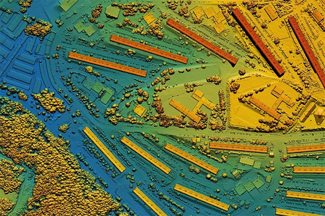
LiDAR is a remote sensing technology that uses laser pulses to measure distances between the sensor and the target surface. It generates precise, high-resolution 3D models of landscapes, structures, and objects by capturing millions of data points per second. This data is then processed to create detailed digital elevation models (DEMs), digital terrain models (DTMs), and point cloud representations.
How Drone-Based LiDAR Works?
Drones equipped with LiDAR sensors fly over an area and emit laser pulses toward the ground. These pulses reflect off surfaces and return to the sensor, where the time taken for the light to return is calculated to determine the distance. By combining this data with GPS and IMU (Inertial Measurement Unit) readings, drones can produce highly accurate 3D maps and terrain models.
Benefits of Drone Surveys with LiDAR
High Accuracy and Precision: LiDAR technology can capture detailed elevation data, even in densely vegetated areas, with sub-centimeter accuracy.
Speed and Efficiency: Drone-based LiDAR surveys are significantly faster than traditional land-based methods, reducing project timelines.
Access to Hard-to-Reach Areas: Drones can survey areas that are difficult, dangerous, or impossible for humans to access, such as rugged terrains, forests, and disaster zones.
Cost-Effectiveness: Using drones for LiDAR surveys reduces the need for expensive manned aircraft or extensive ground surveys, saving time and resources.
Enhanced Safety: Surveying hazardous locations, such as cliffs, construction sites, and disaster-affected areas, can be done remotely without endangering human lives.
Applications of Drone-Based LiDAR Surveys
Topographic Mapping and Land Surveying: LiDAR-equipped drones are used to create accurate topographic maps for infrastructure development, urban planning, and geological studies. The detailed elevation data is essential for engineers and architects designing buildings, bridges, and roads.
Forestry and Environmental Monitoring: Drones with LiDAR sensors help in forest management by mapping tree heights, canopy densities, and biomass. They are also instrumental in tracking deforestation, monitoring wildlife habitats, and assessing environmental changes.
Archaeology and Cultural Heritage Documentation: LiDAR technology enables archaeologists to uncover hidden structures, such as ancient ruins and buried settlements, by penetrating dense vegetation. This non-invasive method helps preserve historical sites while providing detailed insights into past civilizations.
Mining and Quarrying: Drone-based LiDAR surveys are widely used in the mining industry for volume calculations, pit analysis, and terrain mapping. These insights improve resource management and optimize excavation processes.
Disaster Management and Response: In the aftermath of natural disasters like earthquakes, floods, and landslides, LiDAR-equipped drones help emergency responders assess damage, identify hazardous zones, and plan relief efforts efficiently.
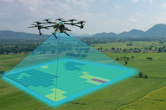
Precision Agriculture: Farmers use LiDAR-equipped drones to analyze crop health, soil conditions, and irrigation needs. This technology helps optimize agricultural productivity and minimize resource wastage.
Challenges and Limitations of Drone LiDAR Surveys
Cost of Equipment: High-quality LiDAR sensors and drones are expensive, making initial investments significant.
Complex Data Processing: LiDAR generates large datasets that require advanced software and expertise to analyze.
Regulatory Restrictions: Drone operations are subject to airspace regulations, requiring permissions and compliance with local laws.
Weather Dependency: Harsh weather conditions, such as heavy rain, fog, or strong winds, can affect data collection accuracy.
Future Trends in Drone-Based LiDAR Mapping
The future of drone-based LiDAR mapping is poised for transformative growth, driven by advancements in technology and increasing demand across industries. Emerging trends include the integration of AI and machine learning for real-time data processing, enabling faster and more accurate analysis of complex terrains. Miniaturization of LiDAR sensors and improved battery life will enhance drone efficiency, allowing for longer flight times and higher-resolution mapping.
Additionally, the rise of autonomous drones and swarm technology will revolutionize large-scale surveying, making it more cost-effective and accessible. As industries like agriculture, construction, and environmental monitoring continue to adopt drone-based LiDAR, its applications will expand, offering unprecedented precision and insights for decision-making. The future promises a seamless blend of innovation and practicality, reshaping how we map and understand the world.
As technology evolves, drone-based LiDAR mapping is expected to become more advanced, accessible, and affordable. Key trends include:
AI and Machine Learning Integration: Automating data analysis to improve efficiency and accuracy.
Miniaturization of LiDAR Sensors: Making drones more lightweight and cost-effective.
Improved Battery Life: Extending flight durations for larger survey areas.
5G and Cloud Computing: Enhancing real-time data processing and sharing capabilities.
Drone Survey Data Classification
Drone surveys have revolutionized data collection by providing high-resolution aerial imagery, point cloud data, and geospatial insights with speed and accuracy. However, raw drone data needs to be processed and classified to extract meaningful information. Drone survey data classification involves organizing and categorizing collected data into different classes based on features, terrain, and object types.
Types of Drone Data Classification
LiDAR Point Cloud Classification: Drones equipped with LiDAR sensors generate dense point clouds that need to be classified into ground, vegetation, buildings, and other objects. This helps in terrain modelling, infrastructure mapping, and forestry analysis.
Orthomosaic Image Classification: High-resolution ortho-mosaic images captured by drones are classified using AI and machine learning algorithms. These images can be used for land use planning, agriculture monitoring, and urban development.
Thermal and Multispectral Data Classification: Drone surveys capture thermal and multispectral data to assess vegetation health, detect heat leaks in buildings, and monitor environmental changes. Classification of this data allows precise analysis in the agriculture, energy, and conservation sectors.
Useful Applications of Drone Data Classification
Construction & Infrastructure: Site monitoring, progress tracking, and safety assessment.
Agriculture: Crop health analysis, irrigation planning, and pest detection.
Forestry & Environment: Deforestation monitoring, wildlife tracking, and disaster management.
Mining & Quarrying: Volume estimation, pit analysis, and stockpile management.
By classifying drone survey data effectively, businesses and government agencies can make data-driven decisions, improve efficiency, and enhance operational safety. With advancements in AI and automation, drone data classification continues to evolve, offering new possibilities for industries worldwide.
Drone surveys combined with LiDAR technology are transforming geospatial data collection, offering unmatched accuracy, efficiency, and versatility. From infrastructure development to disaster management, this innovative approach is shaping the future of various industries. As technological advancements continue, drone-based LiDAR mapping will play an increasingly vital role in modern surveying and mapping applications.
With drone survey and LiDAR data processing, we enhance raw datasets into structured, classified outputs, enabling industries like construction, mining, forestry, and urban planning to optimize their operations. By leveraging automation and manual validation, Polosoft Technologies ensures businesses receive highly accurate, reliable, and actionable geospatial insights for improved efficiency and decision-making.
About the Author
Dillip Rath is a general manager at Polosoft Technologies with a passion for crafting compelling and informative content across diverse industries. A keen interest in Geospatial technology, business development, and digital trends, ensuring the content is both insightful and impactful. Polosoft Technologies specializes in delivering high-accuracy Point Cloud Classification, and Drone Survey LiDAR Data Processing to help businesses make informed decisions.